
Page 92 - Superintendent Report 2021-22
P. 92
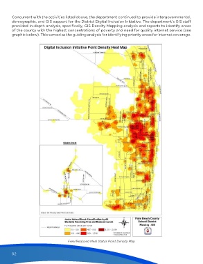
Concurrent with the activities listed above, the department continued to provide intergovernmental,
        demographic, and GIS support for the District Digital Inclusion Initiative. The department’s GIS staff
        provided in-depth analysis, specifically, GIS Density Mapping analysis and reports to identify areas
        of the county with the highest concentrations of poverty and need for quality internet service (see
        graphic below). This served as the guiding analysis for identifying priority areas for internet coverage.


                                          Free/Reduced Meal Status Point Density Map


        92


                                                                                                                 8/23/22   2:55 PM
   Superintendent Report 2021-22.indd   92                                                                       8/23/22   2:55 PM
   Superintendent Report 2021-22.indd   92